Jump to content


Photo

Entering surveyors coordinates


  • Please log in to reply
7 replies to this topic

#1 Jason Lusardi

Jason Lusardi

    Newbie

  • Members
  • Pip
  • 3 posts

Posted 28 January 2015 - 01:09 PM

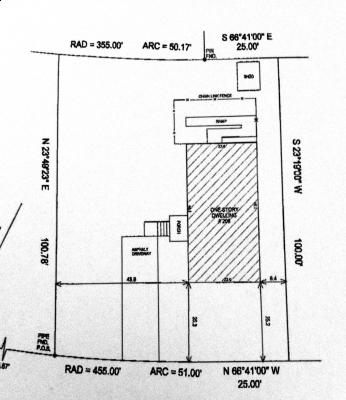
Hello.  New member here.   Tried doing a search but to no avail.   I am trying to enter surveyors coordinates but have no clue what to input when I get to an arc.   The survey I have simply goes from standard coordinates to an arc with the description, rad=455' arc=51.0'


No matter how I try to input this information, regardless of orientation the thing just seems to go haywire.  Can anyone offer some guidance please?  Thanks.  Jay


Pic attached if anyone can help walk me thru this.

Attached Thumbnails

  • survey(1).JPG


#2 Chris Stewart

Chris Stewart

    Advanced Member

  • Banned
  • PipPipPip
  • 238 posts
  • LocationTexas

Posted 28 January 2015 - 02:31 PM

I am not sure that I understand the nature of your problem.


An arc should have a bearing and length just like any other line. I suspect you are missing that info.


All comments are my opinion only and may or may not be correct
-Chris

#3 Fred Russell

Fred Russell

    Advanced Member

  • Members
  • PipPipPip
  • 611 posts

Posted 28 January 2015 - 10:55 PM

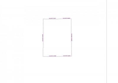
site.jpg


This is using the S66 41 00 E for the curved boundary, which got it close, so need to get the correct curved part coordinance and you have.    or you could experiment if this coordinance is not available


#4 Jason Lusardi

Jason Lusardi

    Newbie

  • Members
  • Pip
  • 3 posts

Posted 29 January 2015 - 07:36 AM

Yes, I agreee I am missing information.   That's why I couldn't get this to close up.  Have contacted surveyor regarding same.   Fred, I appreciate your trick for getting it close.   That could come in handy till I hear back from the surveyor.   Thanks.


#5 Jason Lusardi

Jason Lusardi

    Newbie

  • Members
  • Pip
  • 3 posts

Posted 29 January 2015 - 07:43 AM

Fred,


I ran thru this using your method and got similar results.   Could you please tell me how you got the right hand side line to be vertical?  My entire site boundary is cock-eyed.  Thanks


#6 Chris Stewart

Chris Stewart

    Advanced Member

  • Banned
  • PipPipPip
  • 238 posts
  • LocationTexas

Posted 29 January 2015 - 08:35 AM

Your direction North needs to be parallel with the side you want to be vertical.  


You probably need to read the manual. 


All comments are my opinion only and may or may not be correct
-Chris

#7 Fred Russell

Fred Russell

    Advanced Member

  • Members
  • PipPipPip
  • 611 posts

Posted 29 January 2015 - 10:28 PM

Attached File  Direction of north.pdf   770.69KB   276 downloads


#8 Heath Foster

Heath Foster

    Advanced Member

  • Members
  • PipPipPip
  • 177 posts

Posted 05 February 2015 - 03:16 PM

You could enter the surveyor  coordinates for all the lines but the one you are missing info on then sketch the last one with snap cursor on. Then just enter the radius info. Hope this helps.


0 user(s) are reading this topic

0 members, 0 guests, 0 anonymous users