Jump to content


Photo

Help on survey coordinate plotting

survey plotting coordinates help surveyor coordinates

  • Please log in to reply
34 replies to this topic

#1 Jonathan Verduzco

Jonathan Verduzco

    Advanced Member

  • Members
  • PipPipPip
  • 56 posts
  • LocationCorpus Christi, TX

Posted 29 June 2021 - 11:47 PM

Hello everyone


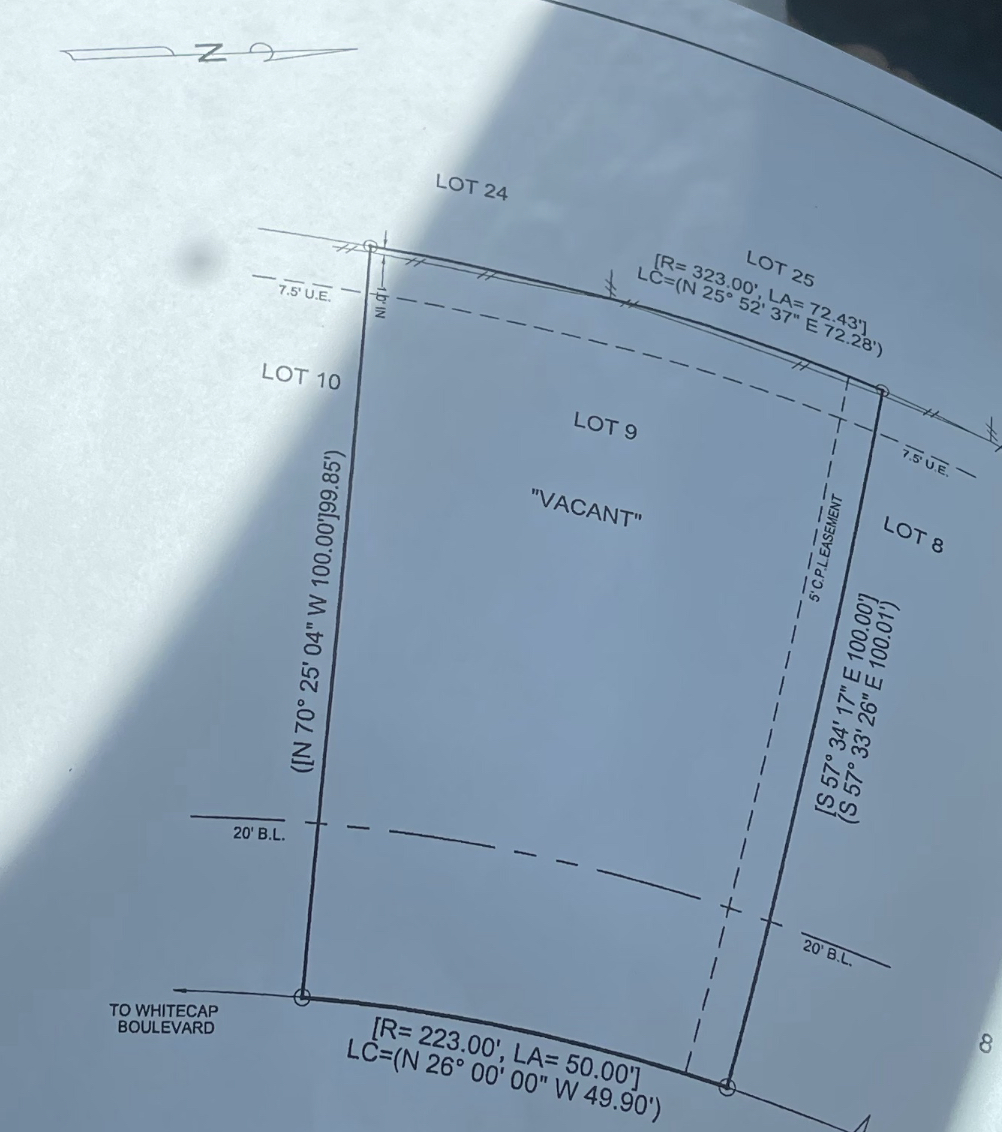
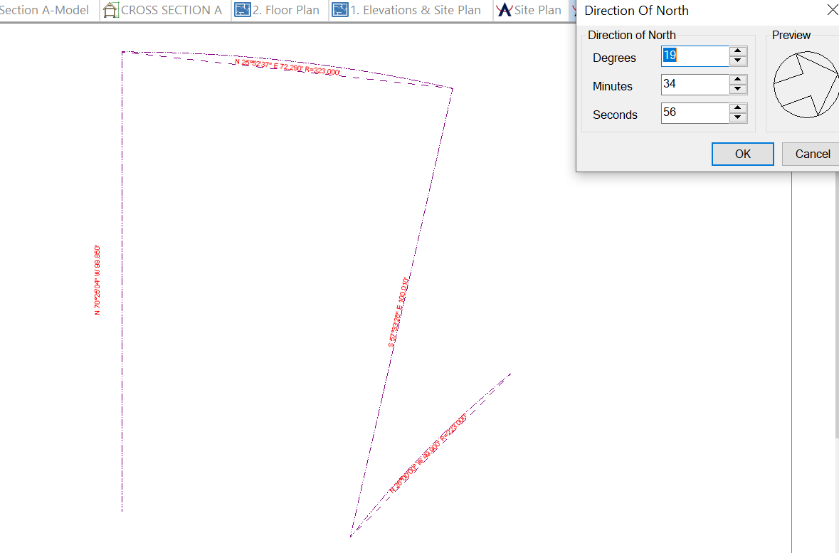
I am a novice at softplan and certainly with plotting surveys. I would appreciate some help with plotting this survey. I can't seem to get the bottom part to go where it needs to go. I've attached a picture of the original survey and my softplan failed attempt.  I've shown what I calculated to get the direction of north. I am not sure if I did that correctly or if I used the correct coordinates from the survey. Thanks for your help in advance!

Attached Thumbnails

  • IMG_6927.jpg
  • Screenshot (14).png


#2 Richard Rubinski

Richard Rubinski

    Advanced Member

  • Members
  • PipPipPip
  • 604 posts
  • LocationWarner Robins, GA.

Posted 30 June 2021 - 03:48 AM

It appears the bottom Coordinates should be NE instead of NW. Someone else may have a different idea.


Attached Files


#3 Keith Almond

Keith Almond

    Advanced Member

  • Members
  • PipPipPip
  • 5,092 posts
  • LocationBrockville, Ontario, Canada

Posted 30 June 2021 - 07:42 AM

I agree with the top arc chord NW, the bottom arc chord NE implies that it is 90 degrees to the top, and it's clearly not.


Keith

There are 10 types of people in this world ....... Those who understand binary, and those who don't.

Softplan user since version 5.5.2.5

www.homehardwarekingston.ca

#4 Jonathan Verduzco

Jonathan Verduzco

    Advanced Member

  • Members
  • PipPipPip
  • 56 posts
  • LocationCorpus Christi, TX

Posted 30 June 2021 - 08:18 AM

It appears the bottom Coordinates should be NE instead of NW. Someone else may have a different idea.


So is the survey wrong?


#5 Jonathan Verduzco

Jonathan Verduzco

    Advanced Member

  • Members
  • PipPipPip
  • 56 posts
  • LocationCorpus Christi, TX

Posted 30 June 2021 - 08:19 AM

I agree with the top arc chord NW, the bottom arc chord NE implies that it is 90 degrees to the top, and it's clearly not.


So this survey can't be plotted with the original coordinates?


  • John Jones likes this

#6 Sam Morgan

Sam Morgan

    Advanced Member

  • Members
  • PipPipPip
  • 842 posts

Posted 30 June 2021 - 09:32 AM

In surveys, NW and SE would be exactly the same...just starting from different sides.  


#7 David Zawadzki

David Zawadzki

    Boss

  • Members
  • PipPipPip
  • 643 posts
  • LocationBoise, Idaho

Posted 30 June 2021 - 09:37 AM

I suggest you scan in the survey image, scale it, and then sketch the property lines.


 who knows what the surveyor was doing/ ;-)


Award winning Design+Builder with over 40 years of construction experience. Homes built in Michigan, Utah and Idaho. Construction projects in CA, AZ, NV, ID, UT, NE, MO, NM, FL, GA, NY, and MI.

https://idahocustomhomes.weebly.com/

Twinmotion 2024, Autocad, SoftPlan 2024, Solidbuilder, Chief Architect X15, Sketchup, 3D Home Architect, etc.

CyberPowerPC Syber Forti SFG9EX Gaming Desktop Computer, Intel Core i9-9900K 3.6GHz, 32GB RAM, 3TB HDD + 1TB SSD, NVIDIA GeForce RTX 3070 10GB, Windows 10 Pro

.Disclaimer: I'm not saying I'm Superman. All I am saying is no one has seen Superman and me in the same room together.<p><p>

Softplan user since 1989

#8 Jonathan Verduzco

Jonathan Verduzco

    Advanced Member

  • Members
  • PipPipPip
  • 56 posts
  • LocationCorpus Christi, TX

Posted 30 June 2021 - 09:59 AM

I suggest you scan in the survey image, scale it, and then sketch the property lines.
 
 who knows what the surveyor was doing/ ;-)


Reasonable solution. I thought I could get the survey precise with using the coordinates. I guess when in doubt trace the survey. Thanks!
  • David Zawadzki likes this

#9 Richard Rubinski

Richard Rubinski

    Advanced Member

  • Members
  • PipPipPip
  • 604 posts
  • LocationWarner Robins, GA.

Posted 30 June 2021 - 09:59 AM

I sent a zip file of the site

#10 Richard Rubinski

Richard Rubinski

    Advanced Member

  • Members
  • PipPipPip
  • 604 posts
  • LocationWarner Robins, GA.

Posted 30 June 2021 - 10:03 AM

I set the north so your building outline is parallel with the small arc

#11 Jonathan Verduzco

Jonathan Verduzco

    Advanced Member

  • Members
  • PipPipPip
  • 56 posts
  • LocationCorpus Christi, TX

Posted 30 June 2021 - 10:06 AM

I sent a zip file of the site


Thanks!!! I noticed some of the coordinates weren’t entered in exactly as shown on survey as far as the degrees, minutes, and seconds. What would be the reason for that?

#12 Keith Almond

Keith Almond

    Advanced Member

  • Members
  • PipPipPip
  • 5,092 posts
  • LocationBrockville, Ontario, Canada

Posted 30 June 2021 - 10:45 AM

Most surveys (in Canada at least) use NORTHINGS. When you draw a continuous boundary then you are drawing the opposite way from the survey notation. as Sam stated earlier, but the angle should stay the same. You can normally edit the survey line when drawing survey coordinates by using the reverse feature.


If a survey doesn't close correctly, then the survey may be slightly off, and the object snapping may cause slight irregularities on the final boundary locations.


In my experience surveys NEVER close exactly ... but they should be pretty damn close. If they are obviously miles out, then you should inform the surveyor ... Even the best of us make errors occasionally.


Keith

There are 10 types of people in this world ....... Those who understand binary, and those who don't.

Softplan user since version 5.5.2.5

www.homehardwarekingston.ca

#13 Richard Rubinski

Richard Rubinski

    Advanced Member

  • Members
  • PipPipPip
  • 604 posts
  • LocationWarner Robins, GA.

Posted 30 June 2021 - 11:26 AM

Are you talking about the coordinates being SE instead of NW. NW is the same as SE. You can edit the edge of any of the edges and reverse them.

#14 Jonathan Verduzco

Jonathan Verduzco

    Advanced Member

  • Members
  • PipPipPip
  • 56 posts
  • LocationCorpus Christi, TX

Posted 30 June 2021 - 12:30 PM

[quote name="Keith Almond" post="35510" timestamp="1625071516"]
Most surveys (in Canada at least) use NORTHINGS. When you draw a continuous boundary then you are drawing the opposite way from the survey notation. as Sam stated earlier, but the angle should stay the same. You can normally edit the survey line when drawing survet coordinates by using the reverse feature.

If a survey doesn't close correctly, then the survey may be slightly off, and the object snapping may cause slight irregularities on the final boundary locations.

In my experience surveys NEVER close exactly ... but they should be pretty damn close. If they are obviously miles out, then you should inform the surveyor ... Even the best of us make errors occasionally.[/quote][quote name="Keith Almond" post="35510" timestamp="1625071516"]

Thanks for the explanation very very helpful!!!

#15 Jonathan Verduzco

Jonathan Verduzco

    Advanced Member

  • Members
  • PipPipPip
  • 56 posts
  • LocationCorpus Christi, TX

Posted 30 June 2021 - 12:33 PM

Are you talking about the coordinates being SE instead of NW. NW is the same as SE. You can edit the edge of any of the edges and reverse them.


I can try reversing them. Thanks!

#16 Richard Rubinski

Richard Rubinski

    Advanced Member

  • Members
  • PipPipPip
  • 604 posts
  • LocationWarner Robins, GA.

Posted 30 June 2021 - 01:31 PM

The top left corner doesn't meet. When I form a polygon it messes up the top coordinates. I missed that on the site plan that I posted. I think it was 5:30 this morning.

Attached Thumbnails

  • SITE PLAN Lot 9.JPG
  • Site Plan-1.JPG
  • Top Left Corner.JPG


#17 Richard Rubinski

Richard Rubinski

    Advanced Member

  • Members
  • PipPipPip
  • 604 posts
  • LocationWarner Robins, GA.

Posted 30 June 2021 - 01:45 PM

It would be nice if you could edit the text for the coordinates like you can with dimensions.

#18 Jonathan Verduzco

Jonathan Verduzco

    Advanced Member

  • Members
  • PipPipPip
  • 56 posts
  • LocationCorpus Christi, TX

Posted 30 June 2021 - 04:25 PM

The top left corner doesn't meet. When I form a polygon it messes up the top coordinates. I missed that on the site plan that I posted. I think it was 5:30 this morning.


What happened to be your coordinates for the direction of north?

#19 Richard Rubinski

Richard Rubinski

    Advanced Member

  • Members
  • PipPipPip
  • 604 posts
  • LocationWarner Robins, GA.

Posted 30 June 2021 - 05:11 PM

26 0 0

Click on the North arrow at the top right

#20 Richard Rubinski

Richard Rubinski

    Advanced Member

  • Members
  • PipPipPip
  • 604 posts
  • LocationWarner Robins, GA.

Posted 30 June 2021 - 05:17 PM

This is a great tutorial

https://softplantuts...ection-of-North


Also tagged with one or more of these keywords: survey, plotting coordinates, help, surveyor, coordinates

0 user(s) are reading this topic

0 members, 0 guests, 0 anonymous users