Jump to content


Photo

Help on survey coordinate plotting

survey plotting coordinates help surveyor coordinates

  • Please log in to reply
34 replies to this topic

#21 Gary Wicklund

Gary Wicklund

    Advanced Member

  • Members
  • PipPipPip
  • 172 posts
  • LocationDuncan BC Canada

Posted 30 June 2021 - 05:41 PM

I still use Acad for site site plans 


still can’t get Softplan surveyor coordinates to work very well, I can’t trust Softplan when the tolerances are tight.


Lately I’ve be getting clients to get a BCLS to do the site plans, they end up pinning the foundation anyways so their ready to go.


also local building Dept requires elevations at the lot corners, building heights and inverts for the services, all info I don’t get during the plan stage.


#22 Jonathan Verduzco

Jonathan Verduzco

    Advanced Member

  • Members
  • PipPipPip
  • 56 posts
  • LocationCorpus Christi, TX

Posted 30 June 2021 - 08:13 PM

This is a great tutorial

https://softplantuts...ection-of-North


Thanks! I appreciate your help.

#23 Jonathan Verduzco

Jonathan Verduzco

    Advanced Member

  • Members
  • PipPipPip
  • 56 posts
  • LocationCorpus Christi, TX

Posted 30 June 2021 - 08:14 PM

Thanks everyone for the help, through everyone’s input I am able to move forward!! Much appreciated!

#24 Jonathan Verduzco

Jonathan Verduzco

    Advanced Member

  • Members
  • PipPipPip
  • 56 posts
  • LocationCorpus Christi, TX

Posted 30 June 2021 - 08:16 PM

I still use Acad for site site plans

still can’t get Softplan surveyor coordinates to work very well, I can’t trust Softplan when the tolerances are tight.

Lately I’ve be getting clients to get a BCLS to do the site plans, they end up pinning the foundation anyways so their ready to go.

also local building Dept requires elevations at the lot corners, building heights and inverts for the services, all info I don’t get during the plan stage.


Interesting. Thanks for your input!!!

#25 Jonathan Verduzco

Jonathan Verduzco

    Advanced Member

  • Members
  • PipPipPip
  • 56 posts
  • LocationCorpus Christi, TX

Posted 30 June 2021 - 10:08 PM

The top left corner doesn't meet. When I form a polygon it messes up the top coordinates. I missed that on the site plan that I posted. I think it was 5:30 this morning.


What is the difference between using the coordinates in the brackets and the coordinates in the parentheses ?

#26 Fred Russell

Fred Russell

    Advanced Member

  • Members
  • PipPipPip
  • 705 posts

Posted 01 July 2021 - 06:01 AM

Problem with this survey is the front coordinance is written wrong on the paper, by the surveyors, change the north to south and leaving the rest makes it work.


question, when the survey shows 2 coordinances for the same line, and usually one is marked M and the other R, what does that signify, and which is best to use for duplicating


#27 Fred Russell

Fred Russell

    Advanced Member

  • Members
  • PipPipPip
  • 705 posts

Posted 01 July 2021 - 07:19 AM

So turns out the problem with the first survey, had a , probably misprint, by the survey company and the front or bottom line on the survey, should have been "S" not the "N" north as shown, and it all fixes and fits.


Question:  like on the right property of Jonathan's survey, it has the 2  different coordinances and lengths. One in brackets and the other in parenthesis.     In florida I always see them marked "M" and "R"


What do these mean. and which should be used when drawing the site.?


#28 Richard Rubinski

Richard Rubinski

    Advanced Member

  • Members
  • PipPipPip
  • 650 posts
  • LocationWarner Robins, GA.

Posted 01 July 2021 - 08:29 AM

SW or NE

#29 Jonathan Verduzco

Jonathan Verduzco

    Advanced Member

  • Members
  • PipPipPip
  • 56 posts
  • LocationCorpus Christi, TX

Posted 06 February 2022 - 03:23 PM

Hello Everyone, I have another site plan that is giving me problems to plot the coordinates. 

I don't have a ton of experience with reading site plans and plats. I would appreciate some 

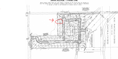
help.. I've attached a screen shot of which lot I am trying to plot including my attempt, and the subdivision site plan. 

Thanks.

Attached Thumbnails

  • Screenshot 2022-02-06 150315.png

Attached Files


#30 Keith Almond

Keith Almond

    Advanced Member

  • Members
  • PipPipPip
  • 5,151 posts
  • LocationBrockville, Ontario, Canada

Posted 06 February 2022 - 03:59 PM

I've done a bit of moving and cropping, but all the required information should be on here.


If you put the chords in first, you should be able to complete the chords without issues.


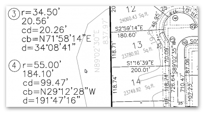
You don't appear to have used the curve data in your site plan. You also have Curve 3 going the wrong way. I haven't tried to plot it but the North East corner of the lot doesn't look like it's in the right place (not your fault), but using the curve data may actually fix that, although it doesn't look to be that far out.


Apart from that, you seem to have used all the bearings and lengths correctly.


2022.02.06_16h50m10s_001_.png


  • Brent Hyndman likes this
Keith

There are 10 types of people in this world ....... Those who understand binary, and those who don't.

Softplan user since version 5.5.2.5

www.homehardwarekingston.ca

#31 Jonathan Verduzco

Jonathan Verduzco

    Advanced Member

  • Members
  • PipPipPip
  • 56 posts
  • LocationCorpus Christi, TX

Posted 06 February 2022 - 04:14 PM

I've done a bit of moving and cropping, but all the required information should be on here.

If you put the chords in first, you should be able to complete the chords without issues.

You don't appear to have used the curve data in your site plan.

2022.02.06_16h50m10s_001_.png


I used the curve data 3 but not 4. I think I need to use curve data 4 also and use radius 55’ and length as 35.11’, right?
  • Brent Hyndman likes this

#32 Keith Almond

Keith Almond

    Advanced Member

  • Members
  • PipPipPip
  • 5,151 posts
  • LocationBrockville, Ontario, Canada

Posted 06 February 2022 - 06:39 PM

Yes, although you'll have to create the entire curve 4 to get it correct and then adjust it back to the corner.


You said you used curve 3, but your plan doesn't show the correct chord bearing ... It should be N71°58'14"E, Your plan shows N72°14'02"E


Keith

There are 10 types of people in this world ....... Those who understand binary, and those who don't.

Softplan user since version 5.5.2.5

www.homehardwarekingston.ca

#33 Jonathan Verduzco

Jonathan Verduzco

    Advanced Member

  • Members
  • PipPipPip
  • 56 posts
  • LocationCorpus Christi, TX

Posted 06 February 2022 - 07:57 PM

Yes, although you'll have to create the entire curve 4 to get it correct and then adjust it back to the corner.

You said you used curve 3, but your plan doesn't show the correct chord bearing ... It should be N71°58'14"E, Your plan shows N72°14'02"E


Yeah it gets funky when I was plugging in all the info for curve 3. But I’ll follow your advice on plotting the whole curve for 4 then adjusting it. Thank you. I’ll check back in.

#34 Jonathan Verduzco

Jonathan Verduzco

    Advanced Member

  • Members
  • PipPipPip
  • 56 posts
  • LocationCorpus Christi, TX

Posted 06 February 2022 - 09:40 PM

Okay this is the best I could do so far. My mistake was that I was putting the cursor two low on screen, in comparison to house and work space, when beginning to enter in coordinates so I would reverse the line and go clockwise entering in coordinates. I put my cursor higher up so to start entering coordinates so I didn't have to reverse the first line and then went counter clockwise. I had to stop the continuity of the lines at curve 4 and adjust it and put it in place. Then I entered in the right and top property lines and placed them in position. The only discrepancy I can see is the top right corner which doesn't connect to right and top property lines. Is this close enough? 


#35 Jonathan Verduzco

Jonathan Verduzco

    Advanced Member

  • Members
  • PipPipPip
  • 56 posts
  • LocationCorpus Christi, TX

Posted 06 February 2022 - 09:41 PM

Here is the pdf of what I got

Attached Files


Also tagged with one or more of these keywords: survey, plotting coordinates, help, surveyor, coordinates

0 user(s) are reading this topic

0 members, 0 guests, 0 anonymous users